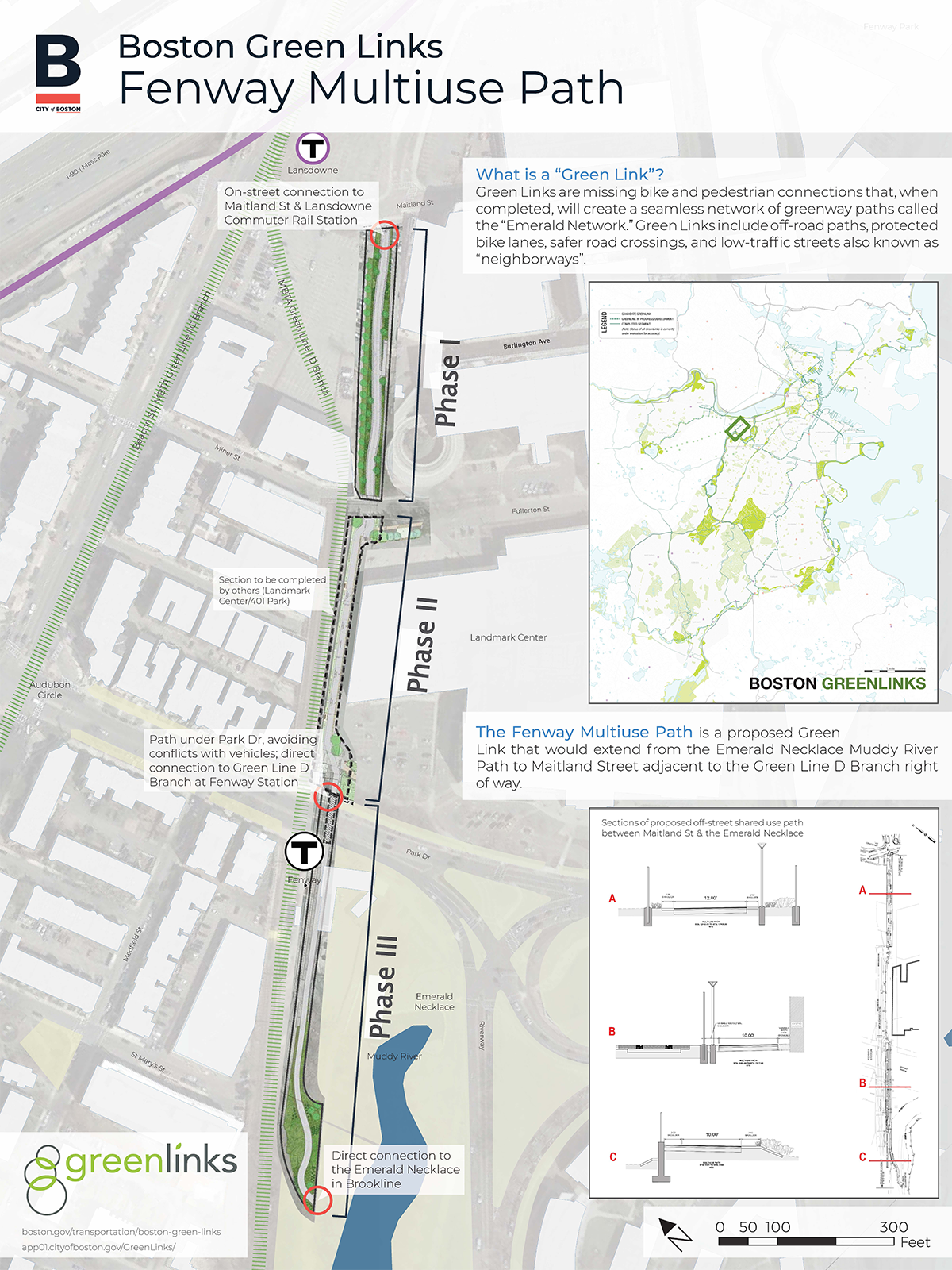
Fenway Multiuse Path
This path will bridge a gap in our bike network by connecting the Emerald Necklace path to Lansdowne Station, Fenway Park, and new separated bike facilities on Beacon Street that lead to Kenmore Square.
The proposed path will connect residents to jobs, public transportation, cultural institutions, and green spaces. Its route crosses under Park Drive along an MBTA-owned parcel. The walk- and bike-friendly path will extend for 1,700 feet.
The path will be completed in phases:
- Phase I, Maitland to Miner: Phase I will be constructed by MassDOT as a TIP project. Construction is scheduled to begin 2021.
- Phase II, Miner to Fenway Station: Phase II will be constructed by the Landmark Center. Construction is anticipated to begin 2021.
- Phase III, Fenway Station to the Emerald Necklace path in Brookline: Phase III requires additional design coordination with the MBTA. Construction would follow the Army Corps of Engineers Muddy River Flood Risk Management Project, which is scheduled to be completed in 2023.
Project Purpose
The Fenway Multiuse Path will be an urban trail along a former CSX rail ROW that is currently owned by the MBTA and MassDOT. The trail will start at the Muddy River path in Brookline and extend to Maitland Street at Lansdowne Commuter Rail Station.
Many people already use the existing Muddy River path, and more people are biking in the area every year. In our 2019 annual bike counts, cyclists represented more than 24% of the peak hour vehicles on Longwood Ave and on Massachussetts Ave in the Back Bay. The need for low-stress cycling opportunities for people who commute as well as people who yearn for safe, social activities in a pandemic couldn't be greater.
Going beyond the northern end of the existing Muddy River Path is daunting for people walking and bicycling. It requires crossing many lanes of traffic on Park Drive going in many directions.
The project will create a low-stress path underneath Park Drive that then continues to provide access to homes and other destinations in the Fenway neighborhood.
The benefits of the path connection along the MBTA tracks, under Park Drive and connecting to the Fenway Center development project, include:
- Extending the multi-use trail from the Muddy River Reservation to Fenway and Yawkey stations. This creates safe bike and pedestrian access to these stations and promotes higher transit ridership.
- A new transportation option for people who live in the neighborhood, as well as people who will live and work in new buildings along the path. Projects in the pipeline next to the path make up over 2 million square feet of new development. This includes more than 400 residential units.
- An alternate walking and bike route for families and bicyclists. They will be able to avoid heavy traffic at Park Drive where it meets the Muddy River.
- A more pleasant and accessible route for Red Sox fans who take the T to Fenway Park.


