New pedestrian wayfinding signs coming to South Boston Waterfront
The new signs are expected to improve mobility by making walking to destinations in the area easier and more pleasurable.
The City of Boston, the Commonwealth of Massachusetts and several partners announced today the implementation of a new pedestrian wayfinding signage program in the South Boston Waterfront neighborhood. The new signs are expected to improve mobility by making walking to destinations in the area easier and more pleasurable. The wayfinding signs are an outcome of the 2015 South Boston Waterfront Sustainable Transportation Plan and they expand upon a one-year 2015 pilot program of pedestrian wayfinding signs developed to guide visitors to and from the Boston Convention & Exhibition Center.
“The Boston Transportation Department and our partners on this important project have pooled our resources and worked together to design a wayfinding signage program that meets the distinct needs of the South Boston Waterfront,” said BTD Commissioner Gina N. Fiandaca. “While the signs are eye-catching and complement the surroundings, they are also functional and work to improve walkability in this busy neighborhood.”
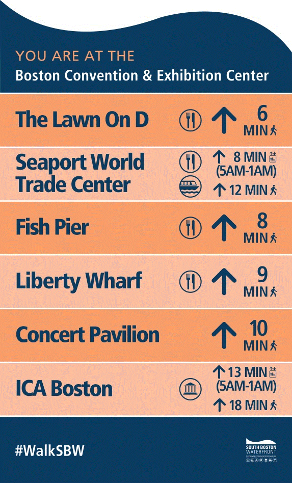
In the last month, after a year-long collaboration, City of Boston and Commonwealth of Massachusetts agencies, working with local organizations, such as, the Seaport TMA, A Better City and Walk Boston, have installed a full network of wayfinding signs at locations in and around the Waterfront from the Flynn Cruiseport to South Station, and the Boston Convention & Exhibition Center’s Lawn on D to Moakley Courthouse. The signs point to and from a variety of destinations, including MBTA connections, museums, event spaces, and dining options. They include information on direction, walk time, and amenities. An example of the signage is pictured below.
“Boston is America’s best walking city and we want to make an already great experience even better by making it easier and more convenient for visitors from around the world to navigate the South Boston Waterfront and enjoy everything it has to offer,” said Jim Folk, MCCA Director of Transportation and Chairman of the South Boston Waterfront Sustainable Transportation Plan Subcommittee on Pedestrian Wayfinding.
“MassDOT is pleased to support the pedestrian wayfinding signs initiative as one step in our commitment to help people navigate easily and therefore increase the likelihood that people will choose to walk or bike to their destinations,” said MassDOT Acting Highway Administrator Jonathan Gulliver. “Wayfinding signs are a very easy tool which absolutely encourages people to think about getting to their destinations without the need to jump into a vehicle.”
All of the time and labor for this project was provided through the program partners below:
- A Better City
- Boston Commission for Persons with Disabilities
- Boston Planning & Development Agency
- Boston Public Works
- Boston Transportation Department
- Massachusetts Bay Transportation Authority
- Massachusetts Convention Center Authority
- Massachusetts Department of Transportation
- Massachusetts Port Authority
- Seaport Transportation Management Association
- WalkBoston.
Partners in the wayfinding signs initiative are interested in the public’s thoughts on the program and the Massachusetts Convention Center Authority will be tracking feedback with the hashtag #WalkSBW. Public feedback will be invaluable for developing the next and more permanent solution to wayfinding in the neighborhood.


